This website provides an online toolbox to calculate a bunch of tropospheric parameters from numerical weather models (NWMs) or radiosonde data, mainly for space geodetic technique (GNSS, InSAR, VLBI, etc.) use. Tropospheric model products, such as the mapping function (WMF) and real-time ZTD grid product (RtZTD), developed at Wuhan University are also released on this website, and near-real-time ZTD/PWV at hundreds of ground-based GNSS stations (mainly in China) routinely processed by us can be visualized here.
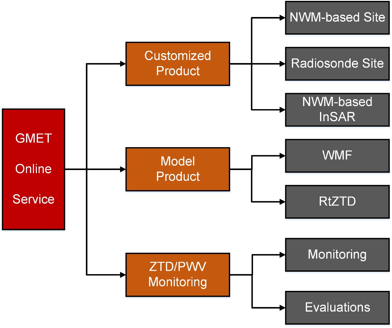
The following diagram illustrates the structure of the GMET online service.
1. Customized Product
Taking inputs from users, GMET online service can calculate tropospheric parameters from NWMs or radiosonde data at the user-required sites or regions. A hyperlink of the result file will be sent to the user’s e-mail box for downloading.
(1) NWMs-based Site
Users input the basic information (user information, site coordinate, time, and NWMs), then tropospheric parameters including the air temperature, air pressure, water-vapor-weighted mean temperature (Tm), water vapor pressure (e), zenith hydrostatic delay (ZHD), zenith wet delay (ZWD), zenith total delay (ZTD), precipitable water vapor (PWV), mapping function coefficients (mfd, mfw), and horizontal gradient (Gn, Ge) can be estimated from the NWMs. The European Centre for Medium-Range Weather Forecasts (ECMWF) ERA5 is currently supported. More NWMs will be supported in the future.
Recommend citations:
◊ Zhang W., Zhang H., Liang H., Lou Y., Cai Y., Cao Y., Zhou Y., Liu W. (2019) On the suitability of ERA5 in hourly GPS precipitable water vapor retrieval over China. Journal of Geodesy. 93, 1897-1909.
◊ Zhou Y., Lou Y., Zhang W., Kuang C., Liu W., Bai J. (2020) Improved Performance of ERA5 in Global Tropospheric Delay Retrieval. Journal of Geodesy. 94:103.
(2) Radiosonde Site
This module can be used to estimate the tropospheric parameters, including the air temperature, air pressure, Tm, ZHD, ZWD, ZTD, and PWV at radiosonde stations based on data archived at the Integrated Global Radiosonde Archive (IGRA).
Recommend citations:
◊ Zhang W., Lou Y., Haase J., Zhang R., Zheng G., Huang J., Shi C., Liu J. (2017) The Use of Ground-based GPS Precipitable Water Measurements over China to Assess Radiosonde and ERA-Interim Moisture Trends and Errors from 1999-2015. Journal of Climate, 30, 7643-7667.
◊ Zhang W., Lou Y., Cao Y., Liang H., Shi C., Huang J., Liu W., Zhang Y., Fan B. (2019) Corrections of Radiosonde-based Precipitable Water Using Ground-based GPS and Applications on Historical Radiosonde Data over China. Journal of Geophysical Research-Atmospheres. 124 (6), 3208-3222.
(3) NWMs-based InSAR
This module can be used to estimate the tropospheric delay correction information by configuring the range and acquisition time of the InSAR observations.
Recommend citation:
◊ Zhang Z., Lou Y., Zhang W., Wang H., Zhou Y., Bai J. (2021) On the Assessment GPS-Based WRFDA for InSAR Atmospheric Correction: A Case Study in Pearl River Delta Region of China. Remote Sensing. 13, 3280.
◊ Zhang Z., Lou Y., Zhang W., Wang H., Zhou Y., Bai J. (2022) Assessment of ERA-Interim and ERA5 Reanalysis Data on Atmospheric Corrections for InSAR. International Journal of Applied Earth Observation and Geoinformation. 111, 102822.
2. Model Product
(1) WMF
The WMF (Wuhan university Mapping Function) model grid products (1°x1°) and site products with temporal resolution of 1 h are distributed via FTP to users. The WMF will provide users tropospheric parameters including the air temperature, air pressure, Tm, e, ZHD, ZWD, ZTD, PWV, mapping function, and horizontal gradient.
Recommend citation:
◊ Zhou Y., Lou Y., Zhang W., Bai J., Zhang Z. (2021) An improved tropospheric mapping function modeling method for space geodetic techniques. Journal of Geodesy. 95:98.
(2) RtZTD
The GMET online service also distributes the real-time ZTD grid products, with spatial and temporal resolution of 1° and 30 min, mainly over China, for high-accuracy navigation or real-time positioning users.
Recommend citation:
◊ Lou Y., Huang J., Zhang W., Liang H., Zheng F., Liu J. (2017) A new zenith tropospheric delay grid product for real-time PPP applications over China. Sensors, 18, 65.
3. ZTD/PWV Monitoring
(1) Monitoring
GNSS observations at several hundreds of GNSS stations are processed by us in near-real-time mode to get ZTD/PWV with 30 min interval. Both the spatial geographical distribution of ZTD/PWV at the latest epoch and time series of ZTD/PWV at all stations can be visualized. ZTD/PWV products at all monitored stations can be provided upon request.
(2) Evaluations
The near-real-time ZTD/PWV solutions are routinely evaluated weekly by comparing with the post-processing solutions, and are illustrated in this module.
GMET is supported by the National Natural Science Foundation of China (No. 41774036 and No. 41804023). We acknowledge the European Centre for Medium range Weather Forecasts (ECMWF) for its ERA5 reanalysis products, the National Oceanic and Atmospheric Administration for its Integrated Global Radiosonde Archive (IGRA) dataset, and the International GNSS Service (IGS), the Crustal Movement Observation Network of China (CMONOC) and National BDS Augmentation Service System (NBASS) for providing GNSS data.
Users are free to use, share, copy and redistribute the data, provided that they properly cite the recommend papers. However, commercial use is not allowed.


 Menu
Menu